Ride Delaware ? Posted February 7, 2013 Report Share Posted February 7, 2013 Models are over the place and I'm not talking about Tyra Banks and Kate Moss. Euro showing 9-12" for Allentown others showing as little as 2-4"... I'm liking the Euro for this, but it seems like the snow amounts are moving farther north... I can't wait for this bad boy to start up!!! Quote Link to comment Share on other sites More sharing options...
Kyle Posted February 7, 2013 Report Share Posted February 7, 2013 Yup foursome me, you, atomicjeff and root Jeff and I vs you an root so we can take your $$$$ 1 Quote Link to comment Share on other sites More sharing options...
Johnny Law Posted February 7, 2013 Report Share Posted February 7, 2013 Models have problems and not just cocaine and trying to stay thin. The NAM is always saying snow for everyone and lots of it. That model is showing 1foot for LV and crazy shit like that. The GFS is almost always too warm and too far east. It shows my hood with jack shit. The EURO is a mix of the previous two, it is normally the best for EC winter but also tends to pull storms too far west. The higher resolution models will start popping up tonight and the next EURO run is this afternoon, these will be probably the most accurate. The key here is the trend, the models earlier in the week said rain for everyone, then like every other storm as it gets closer they trend colder and more west. If you made me put money on it, I'd say this plays the classic EC game and comes in a little colder and more snowy but with dry slots. Local mets will up the snow totals tonight/tommorow morning and you get a decent day at Blue but partiucarly points further north. Ride you shit head ME going to be going off, even better get in your car and drive to S VT. Magic gonna get 20". Quote Link to comment Share on other sites More sharing options...
Kyle Posted February 7, 2013 Report Share Posted February 7, 2013 If Root is as good at golf as you are at being a Darsh we'll win. Root must be pretty damn good at golf then. I was joking obviously. I'm an average golfer at best. Just play for fun. I don't like it when it gets too serious. Quote Link to comment Share on other sites More sharing options...
RootDKJ Posted February 7, 2013 Report Share Posted February 7, 2013 If Root is as good at golf as you are at being a Darsh we'll win. I'm fuckin horrible at golf. Fun to watch though Quote Link to comment Share on other sites More sharing options...
Kyle Posted February 7, 2013 Report Share Posted February 7, 2013 I'm fuckin horrible at golf. Fun to watch though It's more fun to get hammered and see how much shit you can hit with the ball 1 Quote Link to comment Share on other sites More sharing options...
Schif Posted February 7, 2013 Report Share Posted February 7, 2013 My golf has been slacking lately. I find that the only way to really play well is to play all the time. 1 Quote Link to comment Share on other sites More sharing options...
Ride Delaware ? Posted February 7, 2013 Report Share Posted February 7, 2013 Ride you shit head ME going to be going off, even better get in your car and drive to S VT. Magic gonna get 20". I'm stoked... Today was my day off, so I work the next 4 straight, but I'll be able to get it first thing... I got cleared by the doc for the woods, so everything seems to be shaping up well!!! 1 Quote Link to comment Share on other sites More sharing options...
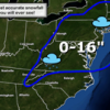
toast21602 Posted February 7, 2013 Report Share Posted February 7, 2013 (edited) 5-10 for LV and 10-15 for rt80 and northern areas. Could be good! Edited February 7, 2013 by toast21602 1 Quote Link to comment Share on other sites More sharing options...
indiggio Posted February 7, 2013 Report Share Posted February 7, 2013 It's more fun to get hammered and see how much shit you can hit with the ball The only way to golf, with a cooler of beer in the back of the cart! Quote Link to comment Share on other sites More sharing options...
toast21602 Posted February 7, 2013 Report Share Posted February 7, 2013 The only way to golf, with a cooler of beer in the back of the cart! Correct! And I still shoot moderately decent as the day goes on! Quote Link to comment Share on other sites More sharing options...
indiggio Posted February 7, 2013 Report Share Posted February 7, 2013 Correct! And I still shoot moderately decent as the day goes on! Seems to be a bell curve with me. Once the right number of beers have been consumed, the scoring ability begins to taper off. 1 Quote Link to comment Share on other sites More sharing options...
NMSKI Posted February 7, 2013 Report Share Posted February 7, 2013 Correct! And I still shoot moderately decent as the day goes on! Same goes for me, I relax with a little buzz and just hit that shit real easy. Quote Link to comment Share on other sites More sharing options...
Johnny Law Posted February 7, 2013 Report Share Posted February 7, 2013 (edited) EURO coming in cold LV 7-12" Reading 4-8" Mt. Pocono 10-14" just text so far now maps until 230ish Edited February 7, 2013 by Johnny Law 1 Quote Link to comment Share on other sites More sharing options...
indiggio Posted February 7, 2013 Report Share Posted February 7, 2013 Same goes for me, I relax with a little buzz and just hit that shit real easy. Always a good way to screw with someone's shot, tell them to hit the ball as hard as they can... Quote Link to comment Share on other sites More sharing options...
Kyle Posted February 7, 2013 Report Share Posted February 7, 2013 Correct! And I still shoot moderately decent as the day goes on! I get better. Or at least I think I do. Quote Link to comment Share on other sites More sharing options...
Johnny Law Posted February 7, 2013 Report Share Posted February 7, 2013 This is a real fucking tricky beast, if it moves 50 miles in either direction the output is wildly different. Interesting thought is that a stall is beginning to show up in the models, the NAO is currently not blocking however if a stall occurs everywhere gets 2x what is currently being predicted. There is a northern stream of energy and a southern stream of energy, how those two come together or phase is 99% of the ball game because it determines the cloud temp and to a certain extent ground level temps. Quote Link to comment Share on other sites More sharing options...
toast21602 Posted February 7, 2013 Report Share Posted February 7, 2013 Always a good way to screw with someone's shot, tell them to hit the ball as hard as they can... ask them if they inhale or exhale when they come down on the ball. fucks with their mind haha. 1 Quote Link to comment Share on other sites More sharing options...
mbike-ski Posted February 7, 2013 Report Share Posted February 7, 2013 (edited) @jl not u toast thaz what i'm talking about - nuff of this golf bullshit! Edited February 7, 2013 by mbike-ski Quote Link to comment Share on other sites More sharing options...
toast21602 Posted February 7, 2013 Report Share Posted February 7, 2013 This is a real fucking tricky beast, if it moves 50 miles in either direction the output is wildly different. Interesting thought is that a stall is beginning to show up in the models, the NAO is currently not blocking however if a stall occurs everywhere gets 2x what is currently being predicted. There is a northern stream of energy and a southern stream of energy, how those two come together or phase is 99% of the ball game because it determines the cloud temp and to a certain extent ground level temps. it could get very interesting. the only way we will know for sure is to wake up saturday and look out the window. Quote Link to comment Share on other sites More sharing options...
vinnyv11 Posted February 7, 2013 Report Share Posted February 7, 2013 it could get very interesting. the only way we will know for sure is to wake up saturday and look out the window. Everything looks so damn varied that I don't know what the f to follow. Really wish I could convince the wife to get in the car tonight and start driving north. Places like Magic and Mount Snow are supposed to be in the heart of it in most models. Quote Link to comment Share on other sites More sharing options...
Johnny Law Posted February 7, 2013 Report Share Posted February 7, 2013 it could get very interesting. the only way we will know for sure is to wake up saturday and look out the window. I have realized over the years I obsess on just a couple of things, one is winter weather models. LOL Could you pick anything more lame to obsess over than winter weather models and skis hahahahah Quote Link to comment Share on other sites More sharing options...
indiggio Posted February 7, 2013 Report Share Posted February 7, 2013 ask them if they inhale or exhale when they come down on the ball. fucks with their mind haha. Yup, that one works well too! Ski The East tweet: **THE NATIONAL HYPE SERVICE HAS ISSUED A WTF EVERYONE IS FREAKING OUT ADVISORY FOR THE NORTHEAST** 3 Quote Link to comment Share on other sites More sharing options...
thebeezneez Posted February 7, 2013 Report Share Posted February 7, 2013 Which mountain should I go to for this storm? Camelback or Mtn. Creek? Quote Link to comment Share on other sites More sharing options...
toast21602 Posted February 7, 2013 Report Share Posted February 7, 2013 * ACCUMULATIONS... SNOW ACCUMULATION OF 10 TO 16 INCHES... ALONG WITH POSSIBLY A TRACE OF ICE. * TIMING... SNOW FRIDAY MORNING WILL PROBABLY CHANGE BRIEFLY TO SLEET AND RAIN DURING THE DAYLIGHT HOURS FROM NEAR ALLENTOWN EASTWARD TO NEAR FLEMINGTON AND SOMERVILLE NEW JERSEY. THEREAFTER... THE HEAVIEST SNOW IS EXPECTED LATE IN THE DAY AND FRIDAY NIGHT WITH ONE TO 2 INCH PER HOUR ACCUMULATIONS. NORTHERLY WINDS WILL GUST TO 30 MPH CAUSING BLOWING AND DRIFTING. THERE IS A SMALL CHANCE OF A THUNDERSTORM WITH THE SNOW. 1 Quote Link to comment Share on other sites More sharing options...
Recommended Posts
Join the conversation
You can post now and register later. If you have an account, sign in now to post with your account.