GrilledSteezeSandwich Posted March 25, 2023 Report Posted March 25, 2023 4 minutes ago, EdBacon said: There was also a ski area operating on Camelback Mountain before the extant Camelback was opened in the 60s. Big Pocono Ski area opened for the 1950/51 season and closed in 1955 before ski operations moved slightly west down the mountain and the ski area's investors opened the current Camelback. The old pickup truck used to power the original rope tow is still in the woods off Nile Mile. I know they're not counting that in the date but you gave me an opening to talk about ski area history. Radical. Are you riding Blue tomorrow? I remember you saying you have a season pass there now. 1 Quote
EdBacon Posted March 25, 2023 Report Posted March 25, 2023 15 minutes ago, GrilledSteezeSandwich said: Radical. Are you riding Blue tomorrow? I remember you saying you have a season pass there now. No. Fiancee and I are moving into a new place so I'm looking for a dining room table this weekend. 1 Quote
Benm Posted March 25, 2023 Report Posted March 25, 2023 55 minutes ago, GrilledSteezeSandwich said: Nope I didn’t go this AM and of course the rain just started right before 10. All good tomorrow is gonna be epic!!! Missed a good day. 1 Quote
momskeeztoo Posted March 26, 2023 Report Posted March 26, 2023 11 hours ago, EdBacon said: There was also a ski area operating on Camelback Mountain before the extant Camelback was opened in the 60s. Big Pocono Ski area opened for the 1950/51 season and closed in 1955 before ski operations moved slightly west down the mountain and the ski area's investors opened the current Camelback. The old pickup truck used to power the original rope tow is still in the woods off Nile Mile. I know they're not counting that in the date but you gave me an opening to talk about ski area history. Interesting. Was the ski area part of what is Big Pocono SP now? Quote
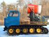
EdBacon Posted March 27, 2023 Report Posted March 27, 2023 (edited) On 3/25/2023 at 10:31 PM, momskeeztoo said: Interesting. Was the ski area part of what is Big Pocono SP now? The old trails would have been skiers right of Nile Mile. The longest tow went about 2/3rds of the way up the mountain. The top of the Stevenson quad would be in the top right of this old photo. I don't think this is part of the state park. At least not all of it. The top of the mountain is state park land but it doesn't extend all the way to the bottom on the north side. Edited March 27, 2023 by EdBacon 7 1 Quote
RidgeRacer Posted March 28, 2023 Report Posted March 28, 2023 15 hours ago, EdBacon said: The old trails would have been skiers right of Nile Mile. The longest tow went about 2/3rds of the way up the mountain. The top of the Stevenson quad would be in the top right of this old photo. I don't think this is part of the state park. At least not all of it. The top of the mountain is state park land but it doesn't extend all the way to the bottom on the north side. Looks better than than it does today. Any vintage waterslide photos? 1 Quote
EdBacon Posted March 29, 2023 Report Posted March 29, 2023 (edited) On 3/28/2023 at 8:59 AM, RidgeRacer said: Looks better than than it does today. Any vintage waterslide photos? The main problem with siting the trails on the east side of the mountain is that the bottom is mostly floodplain. The original ski area had issues where the ground at the base of the tows wouldn't freeze and you'd be stuck walking through a swamp. It's a big reason why they moved the operations further west down the mountain. Also, on the occasion there's adequate snowfall: skiers right of Nile Mile, right around the first left switchback turn if you duck into the woods you'll come out onto a woods trail that proceeds steeply down towards the old railroad grade. This wasn't a Big Pocono ski trail but it does cross into the old ski area. From there you have to skin or hike back to Nile Mile. No water slide, but imo something better. Check this out: Edited March 29, 2023 by EdBacon 4 Quote
GrilledSteezeSandwich Posted March 29, 2023 Report Posted March 29, 2023 4 minutes ago, EdBacon said: The main problem with siting the trails on the east side of the mountain is that the bottom is mostly floodplain. The original ski area had issues where the ground at the base of the tows wouldn't freeze and you'd be stuck walking through a swamp. It's a big reason why they moved the operations further west down the mountain. Also, on the occasion there's adequate snowfall: skiers right of Nile Mile, right around the first left switchback turn if you duck into the woods you'll come out onto a woods trail that proceeds steeply down towards the old railroad grade. This wasn't a Big Pocono ski trail but it does cross into the old ski area. From there you have to skin or hike back to Nile Mile. No water slide, but imo something better. Check this out: When I first went to camelback summer of 1988 they had two alpine slides and bumper boats. Quote
GrilledSteezeSandwich Posted March 29, 2023 Report Posted March 29, 2023 I think the lodge in the upper left picture is still there unless they tore it down and built something fancy.. Quote
momskeeztoo Posted March 30, 2023 Report Posted March 30, 2023 Oh yeah, the old Alpine Slide. That thing was a blast! Quote
momskeeztoo Posted March 30, 2023 Report Posted March 30, 2023 12 hours ago, GrilledSteezeSandwich said: I think the lodge in the upper left picture is still there unless they tore it down and built something fancy.. Last time I was there was probably 3 years ago. That lodge was still there Quote
RidgeRacer Posted November 25, 2023 Report Posted November 25, 2023 (edited) I think they already have a set opening of 12-15 or some like that. Now that they're both under the same ownership...I wonder if cambelback is becoming the ksl version of big boulder, like in the Vail JFBB relationship. Sort of like blues smaller, overflow mountain that gets less priority Edited November 25, 2023 by RidgeRacer 1 Quote
Schif Posted November 25, 2023 Report Posted November 25, 2023 31 minutes ago, RidgeRacer said: I think they already have a set opening of 12-15 or some like that. Now that they're both under the same ownership...I wonder if cambelback is becoming the ksl version of big boulder, like in the Vail JFBB relationship. Sort of like blues smaller, overflow mountain that gets less priority Camelback as the smaller overflow mountain? I can't possibly imagine that. There's no way that camelback, from a business perspective, is anyone's little brother. Blue is the black sheep brother in the family, but at this point the parents have finally put their foot down and Blue needs to try to get it's shit together. I see it as CBK as the older brother who has had a nice comfortable accounting job and a family for a while and Blue just got forced to go back to community college. 3 Quote
enjoralas Posted November 25, 2023 Report Posted November 25, 2023 (edited) 39 minutes ago, RidgeRacer said: I think they already have a set opening of 12-15 or some like that. Now that they're both under the same ownership...I wonder if cambelback is becoming the ksl version of big boulder, like in the Vail JFBB relationship. Sort of like blues smaller, overflow mountain that gets less priority I think those are flipped. I would bet KSL looks at Blue as complementing their crown jewel of Camelback, if they're taking that sort of look at things. Just take a look at the lifts both got last year. The only reason that they have their opening day set for 12/15 is because of their instance on opening the lookers right part of the mountain first, so they need more night of snowmaking to cover all the concrete and the lazy river. PASR operates in a blue colored echo chamber, but I think that outside of here and the other Blue Mt passholder diehards the majority of the ski community as well as the General Public considers Camelback the superior resort. Or would, if they considered them at all. I know I would rather ski at Blue, but if I had to pick one to own or invest in, as they sit right now it would be Camelback by a mile. Edited November 25, 2023 by enjoralas 2 Quote
DiMe Posted November 25, 2023 Report Posted November 25, 2023 34 minutes ago, enjoralas said: I think those are flipped. I would bet KSL looks at Blue as complementing their crown jewel of Camelback, if they're taking that sort of look at things. Just take a look at the lifts both got last year. The only reason that they have their opening day set for 12/15 is because of their instance on opening the lookers right part of the mountain first, so they need more night of snowmaking to cover all the concrete and the lazy river. PASR operates in a blue colored echo chamber, but I think that outside of here and the other Blue Mt passholder diehards the majority of the ski community as well as the General Public considers Camelback the superior resort. Or would, if they considered them at all. I know I would rather ski at Blue, but if I had to pick one to own or invest in, as they sit right now it would be Camelback by a mile. Nailed it Blue if your primary care is terrain. CBK King if you want full resort experience. 1 Quote
JFskiDan Posted November 25, 2023 Report Posted November 25, 2023 2 hours ago, Schif said: Camelback as the smaller overflow mountain? I can't possibly imagine that. There's no way that camelback, from a business perspective, is anyone's little brother. Blue is the black sheep brother in the family, but at this point the parents have finally put their foot down and Blue needs to try to get it's shit together. I see it as CBK as the older brother who has had a nice comfortable accounting job and a family for a while and Blue just got forced to go back to community college. i think this is pretty accurate. Cameltoe is the son that the KSL hopes that one day Blue will be. Toe is a money making machine year round pretty much, and Blue is the frat brother on the 5 year college plan. i dont like it as much as the next guy, but what works at Toe, is gonna be forced on the drunken frat brother. 1 Quote
RidgeRacer Posted November 25, 2023 Report Posted November 25, 2023 As long as blue gets the earlier opening I'm good (although cbk did close a week later last year) 1 Quote
DiMe Posted November 25, 2023 Report Posted November 25, 2023 17 minutes ago, RidgeRacer said: As long as blue gets the earlier opening I'm good (although cbk did close a week later last year) I think they will prob keep it this way. It's been kind of this eay as long as I can remember with CBK doing the alien pass day at the very end most of the time. Quote
indiggio Posted November 26, 2023 Report Posted November 26, 2023 I think they view Blue as the Uncle Eddie to Cameltoe’s Clark Griswold. Cameltoe thinks it’s something special, putting on all the chincy, flashy tchotchkes and stuff wanting to be like Aspen or Vail, but it’s really Uncle Eddie that’s having all the knucklehead fun. It’s surprising that they’ve not given Blue old hand-me-down equipment. 1 Quote
EdBacon Posted November 26, 2023 Report Posted November 26, 2023 Camelback is older and more comfortable with where they are. They're less motivated to make big changes. Which I can sort of appreciate. They have a stable of old fixed grip lifts still while Blue is all high speed now. They did build out the hotel and waterpark thing in 2015 but otherwise I can't think of any major improvements on the mountain recently. Their new high speed lift is only going in because the lift it replaced had a major accident. 1 Quote
RidgeRacer Posted November 28, 2023 Report Posted November 28, 2023 I forgot that the new lift has a bubble to protect you from the harsh elements in the high elevation, alpine zone at camelback. And while It’s difficult to view the krummholz as you rise through the thin air, it is cool none the less as you’ll remain @toast21602-y for the duration of your ascent. 1 Quote
EdBacon Posted November 28, 2023 Report Posted November 28, 2023 8 hours ago, RidgeRacer said: I forgot that the new lift has a bubble to protect you from the harsh elements in the high elevation, alpine zone at camelback. And while It’s difficult to view the krummholz as you rise through the thin air, it is cool none the less as you’ll remain @toast21602-y for the duration of your ascent. Camelback's base is about the same elevation as the top of Blue Mountain. Quote
DiMe Posted November 28, 2023 Report Posted November 28, 2023 They announced today they're sticking with the Dec 15 opening date. Bold move but they may be able to open 100% just in time for the Christmas crowds!! Quote
GrilledSteezeSandwich Posted November 28, 2023 Report Posted November 28, 2023 10 minutes ago, DiMe said: They announced today they're sticking with the Dec 15 opening date. Bold move but they may be able to open 100% just in time for the Christmas crowds!! Was the same last season they opened three weeks later than Blue and only had a handful of runs open. Quote
Recommended Posts
Join the conversation
You can post now and register later. If you have an account, sign in now to post with your account.